Brownfields Overview
What Are Brownfields?
“A brownfield is a property, the expansion, redevelopment, or reuse of which may be complicated by the presence or potential presence of a hazardous substance, pollutant, or contaminant.”
(Small Business Liability Relief and Brownfields Revitalization Act,” PL 107-118 11 January 2002.)
Communities throughout the Coalition region have properties that are abandoned, blighted, or underused. Typically, but not always, these are industrial or commercial properties which can vary by size. Examples of Brownfields include: gas stations, dry cleaning facilities, old schools, landfills, old mines, refineries and manufacturing facilities. The expansion or redevelopment of these properties, or Brownfields, is complicated by real or perceived environmental contamination. Often, the mere fear of environmental contamination can result in a property being removed from consideration for redevelopment or reuse.
Why is Redevelopment of Brownfields Important?
Brownfields are not just found in big cities. Several communities within the RDSBC region have suffered economically during the past several decades due to declines or closures of important local industries. As a result, many brownfields of various types and conditions are available for redevelopment opportunities. These brownfields often have excellent business locations, with access to transportation and existing infrastructure.
The Coalition’s brownfield program is an important tool to assist the economic development efforts in the region. It fits with other economic development assistance and resources to address liability protection, reuse incentives, revitalization efforts, and is an important part of a comprehensive economic development program.
Communities should encourage redevelopment of brownfields opportunities as part of their overall economic development strategies in order to reuse existing infrastructure, encourage adaptive reuse of existing buildings, remove blight, promote neighborhood revitalization, as well as enhance overall community health and welfare. This strategy will also increase tax bases and revenues, create jobs and improve the appearance of the entire community.
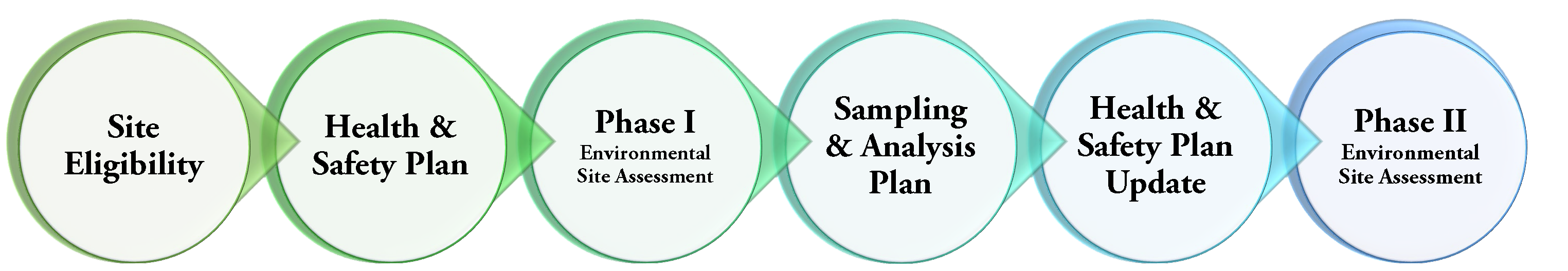
What is the Brownfields Process?
- Identify Potential Brownfields Properties
- Assess Environmental Conditions: Phase I and Phase II Environmental Site Assessments
- Cleanup
- Sustainable Redevelopment
Community outreach and involvement efforts should focus on the affected community and be coordinated with Phase I and II assessments. Property owners, neighborhood associations, developers, financial institutions and community organizations are involved in these and subsequent phases. Following the assessment phases, the site enters the Clean-Up Phase which must be aligned to a reuse or redevelopment option. EPA’s Brownfields Program provides grants to fund environmental assessment, cleanup, and job training activities. Other resources may be available, along with private/public sector investment, to assist in the effort.
RDSBC Assessed Brownfields Sites
Many properties have undergone or are currently undergoing Environmental Site Assessments (ESAs) under the RDSBC program. The table below lists the 30 RDSBC assessment sites. The Site Name (CLICK ON SITE NAME TO VIEW OR DOWNLOAD THE FACTSHEET), Coalition Member, Parcel-ID and acreage are listed in the table. Note that single factsheets have been prepared for sites with multiple parcels. For more information on a site and associated redevelopment opportunities, visit the “Members” dropdown menu and select the Member of interest. See the section titled “Brownfield Properties.”
![]()
| RDSBC PROJECT SITE NAMES / FACTSHEETS | MEMBER | PARCEL |
ACREAGE |
| Coaldale Junction Truck Stop | Esmeralda | 006-161-09 |
40 |
| Dew Drop Inn | Esmeralda | 002-052-04 |
1.27 |
| Old Gas Station and Convenience Store | Esmeralda | 002-053-01 and 002-053-02 |
0.85 |
| Silver Peak Motel | Esmeralda | 002-061-03 |
0.77 |
| Mt. Whitney Fish Hatchery | Inyo | 022-070-06 |
40 |
| Wye Road Properties | Inyo | 010-490-12-00 and 010-490-12-02 |
5.47 |
| PPG Industries Bartlett Plant | Inyo | 029-100-63 |
100 |
| Pahranagat Valley High School Auto Shop | Lincoln | Portion of 004-101-01 |
5,670 sq. ft. |
| Pahranagat High School Multi-Use Building | Lincoln | 004-101-01 |
7.5 |
| Cinema Building | Mineral | 001-134-11 |
0.13 |
| Isom Property | Mineral | 006-670-09 |
19.72 |
| Mineral County School District Administration Building | Mineral | 001-162-03 |
0.69 |
| Mina School | Mineral | 003-034-05 |
1.55 |
| Sixth Street School | Mineral | 001-133-03 |
1.72 |
| Mountain Falls Gateway (045-011-19 and 045-011-23) 2 sites* |
Nye | 045-011-19 |
3.44 |
| Nye | 045-011-23 |
7.64 |
|
| Pahrump Utility Company, Inc. (PUCI) 19 Sites* | |||
| Manse Tank | Nye | 047-041-27 |
1.00 |
| Manse Well 1 | Nye | 047-021-27 |
0.23 |
| CAAS Well 2 | Nye | 047-021-21 |
0.12 |
| Well 3 | Nye | 045-101-62 |
0.23 |
| Well 3b | Nye | 045-101-61 |
0.31 |
| Artesia Water Tank | Nye | 043-121-11 |
0.46 |
| Well 4 | Nye | 043-121-13 |
0.29 |
| Well 5 | Nye | 043-062-12 |
0.22 |
| Well 6 | Nye | 045-151-30 |
0.38 |
| Bowman Well 7 | Nye | 045-101-57 |
0.23 |
| Bowman Well 8 | Nye | 045-101-58 |
0.23 |
| Bowman Well 9 | Nye | 045-101-54 |
0.23 |
| Pleasant Valley Well 1 | Nye | 044-561-29 |
0.11 |
| Pleasant Valley Tank & Well 2 | Nye | 044-561-26 |
0.46 |
| Sewer Plant 600 k | Nye | 045-171-72 |
4.48 |
| Future Sewer | Nye | 045-361-05 |
39.19 |
| Artesia Lift Station | Nye | 045-171-65 |
0.24 |
| Pleasant Valley Lift Station | Nye | 044-891-08 |
0.03 |
| Burson Ranch Lift Station | Nye | 045-551-09 |
0.01 |
| Nye County Public Works Buildings 1 and 2 | Nye | Portion of 008-121-07 |
0.24 |
| Tonopah FBO Building | Nye | 012-471-03 |
0.75 |
| Tonopah Library Expansion | Nye | 008-139-12 |
0.13 |
| Six-Acre Sub-Parcel of Tonopah Airport Parcel 2 | Nye | Portion of 012-471-02 |
6 acres |
| Silver Strike Motel AKA the Pink Motel | Nye | 08-064-01 and 08-063-03 |
1.54 |
| Central Ely School | White Pine | 001-123-02 |
0.29 |
| Hughes Parcels 03 and 04 | White Pine | 001-271-03 and 001-271-04 |
0.77 |
| Lee Vacant Commercial Properties (001-171-05, 001-171-06, and 001-171-07) 3 sites* | White Pine | 001-171-05 |
0.11 |
| White Pine | 001-171-06 |
0.34 |
|
| White Pine | 001-171-07 |
0.11 |
|
| McGill Ball Park | White Pine | 004-034-01 |
4.75 |
| McGill Library | White Pine | 004-071-02 |
0.67 |
* Assessed sites with multiple parcels within the same general location are included in a single factsheet.
RDSBC Assessed Brownfields Site Maps
Maps of the RDSBC Region Brownfield sites are available below. CLICK on the map to view or download a letter page size PDF version.